Human Interest
198.9K views | +2 today
Follow
Human Interest
Your new post is loading...
Scooped by Skuuppilehdet
Scoop.it!

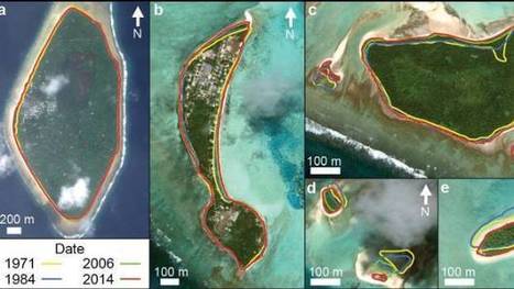
Pacific nation Tuvalu has grown by 73 hectares over 40 years

Pacific nation Tuvalu has grown by 73 hectares over 40 years | Human Interest | Scoop.it

"The tiny Pacific nation of Tuvalu – once thought to be under threat from rising sea levels – has grown the size of California's Disneyland over the past 40 years. It's mostly thanks to waves dumping extra sediment, sand and gravel on shore lines, according to research by Auckland University scientists. The study, published in the Nature Communications journal on Friday, was the first in-depth look at how much each of Tuvalu's 101 islands have changed over the decades."


Tags: Oceaniawatercoastal, environment, physical, geomorphology, erosiongeology, landforms.

No comment yet.
Rescooped by Skuuppilehdet from Stage 4 Landforms & Landscapes
Scoop.it!

Death Valley's Roving Rocks

Death Valley,California - Giant boulders in the desert look as though their moving all on their own! But could weird weather be behind these roving rocks

Via GTANSW & ACT
GTANSW & ACT's curator insight, September 8, 2016 12:06 AM

Engage students in this topic with this mysterious event as a way to introduce geomorphic processes 


Ask inquiry questions related to geomorphic processes eg how do plants and animals cause weathering.


Use images as a basis for inquiry and discussion 


Syllabus links


Students investigate different landscapes and the geomorphic processes that create distinctive landforms, for example: 

- explanation of geomorphic processes that create landforms eg weathering, erosion, deposition, tectonic activity

- examination of ONE landscape and its distinctive landforms 


Rescooped by Skuuppilehdet from AP HUMAN GEOGRAPHY DIGITAL STUDY: MIKE BUSARELLO
Scoop.it!

Lakes On A Glacier

"How deep is that icy blue water on Greenland's ice sheet? Dr. Allen Pope, of the National Snow and Ice Data Center, is using data from the NASA/USGS Landsat 8 satellite to find out. In this video, Dr. Pope shares what he sees when he looks at a Landsat image of the Greenland ice sheet just south of the Jakobshavn Glacier.

Because the lakes are darker than the ice around them, they absorb more energy from the sun. A little bit of melt concentrates in one place, and then melts more, establishing a feedback mechanism accelerating the growth of the lake. When the lakes get big enough they can force open fractures that then drill all the way down to the bed of the glacier, transporting this water to the base where it can temporarily speed up the flow of the ice."


Tags: physical, geomorphology, landforms, erosion, climate change, Greenland, remote sensing, geospatial.


Via Mike Busarello's Digital Storybooks
Courtney Barrowman's curator insight, September 8, 2015 1:06 PM

unit 1 and summer read

Rescooped by Skuuppilehdet from Stage 4 Landforms & Landscapes
Scoop.it!

Tide Makes Tombolo an Island

Tide Makes Tombolo an Island | Human Interest | Scoop.it
The historic abbey of Mont Saint-Michel became an island on March 21 after a rare “supertide” flooded a causeway.

Via GTANSW & ACT
West Sound Tech Assn's curator insight, March 25, 2015 8:32 PM

Not techy but very cool!

Jacob McCullough's curator insight, May 26, 2015 5:24 PM

this was interesting mother nature shows us once again that she is in control by showing us how easily our seemingly strong structures can be swept away    

Rescooped by Skuuppilehdet from AP HUMAN GEOGRAPHY DIGITAL STUDY: MIKE BUSARELLO
Scoop.it!

Eerie Landforms

Eerie Landforms | Human Interest | Scoop.it

Utah's Fantasy Canyon features mudstone eroded into bizarre shapes. This one's called "Flying Witch". #Halloween


Tags: physical, geomorphology, erosion, landforms, Utah.


Via Mike Busarello's Digital Storybooks
No comment yet.
Scooped by Skuuppilehdet
Scoop.it!

Mystery of Death Valley's 'Sailing' Stones Solved

Mystery of Death Valley's 'Sailing' Stones Solved | Human Interest | Scoop.it
There's a place in Death Valley National Park where a mystery that has puzzled scientists and park visitors for decades finally has been solved.
Riaz Ahmad Baboojee's curator insight, August 29, 2014 12:59 AM

Think

Greg Russak's curator insight, August 29, 2014 9:30 AM

It's probably not what you think. It wasn't what I thought.....then again, I had no idea what was happening.

Jake Red Dorman's curator insight, October 29, 2014 1:46 PM

It's amazing to see that even though we have been on this planet for so long, there are stilll mysteries such as this. Tjis could have taken year s to solve but looking at the picture in the slides at the bottom of the article, it seems like this group of scientists knew exactly how to figure this out. this all happens becasue of geography and where these rocks are in the world that make them move around. Iis in a dried up lake pond that freezes over at night to create a layer of ice strong enough to help the rocks move around at night. This discovery took 2 whole years to figure out, but was vey much worth it in the end. 

Scooped by Skuuppilehdet
Scoop.it!

Block-Long Sinkhole Swallows Cars in Baltimore

Block-Long Sinkhole Swallows Cars in Baltimore | Human Interest | Scoop.it

"A block-long sinkhole opened up in a residential neighborhood in rain-soaked Baltimore on Wednesday, devouring cars and forcing the evacuation of several houses."

Jim Doyle's curator insight, May 9, 2014 10:57 PM
Block-Long Sinkhole Swallows Cars in Baltimore
Scooped by Skuuppilehdet
Scoop.it!

Aerial Photographs Catalogue the Life and Death of Volcanic Islands

Aerial Photographs Catalogue the Life and Death of Volcanic Islands | Human Interest | Scoop.it

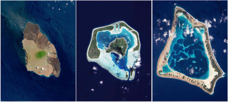
Volcanic islands can seem to appear out of nowhere, emerging from the ocean like breaching monsters of the deep. Below, Mika McKinnon explains how these odd geological formations are born, how they evolve, and how they eventually vanish back beneath the waves.

Matthew Richmond's curator insight, December 2, 2015 3:30 PM

Re-scooped from Professor Dixon, pretty cool story on the formation of islands in the south Pacific. A couple of them look like the island visible from the beach in Rincon, Puerto Rico where I stayed. The island is one giant rock so nobody lives there and it's a naval base for the U.S. military. This, however, is a different situation when you realize that not only do people live here, but kind of a lot of people live here.

Matt Ramsdell's curator insight, December 14, 2015 9:00 PM

What causes the death and the caldera in a volcano? One thing that happens in a deceased volcano is the center of the volcano starts to either erode or the inside finally caves in. Once this happen a caldera takes shape and the ocean starts to take over. As the waves eat away at the shores it will eventually create a island that is shaped like a "U". After this happens that island will someday retreat back into the ocean and someday form a barrier reef.

Adam Deneault's curator insight, December 14, 2015 10:52 PM

Based on general knowledge, I know that the taller a volcano is, the younger it is and the shorter it is, the older it is. The reason they start to get short is from erosion. Hot spots in the Earth's crust make small islands from molten rock. Young islands can be very dangerous, because if they are inhabited, they have the possibility of erupting, whereas an old island does not since the volcano is lnactice and eroding. Over time the inactive volcano will crumble and a caldera will take shape and after even more time, that caldera will slip under the ocean and become a reef. 

Scooped by Skuuppilehdet
Scoop.it!

Heart-shaped landscapes

Heart-shaped landscapes | Human Interest | Scoop.it

The top image is of a mangrove stand in New Caledonia, Glaslyn (Blue lake) is in Northern Wales and this cave is in the 4 corners region of the United States. 

Dixie Conner's curator insight, February 14, 2014 12:11 PM

Happy Valentine's Day

Estelblau's comment, February 14, 2014 4:03 PM
Really great ;)!
Estelblau's comment, February 14, 2014 4:03 PM
Really great ;)!
Scooped by Skuuppilehdet
Scoop.it!

The Whale's Tail

The Whale's Tail | Human Interest | Scoop.it

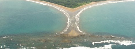
"The Ballena Marine National Park is located in Puntarenas, at the South Pacific coast of Costa Rica." 

Alexander peters's curator insight, October 24, 2016 12:23 PM
This article was about the whale and how they were repopulating and how the whale hunting was banned in the 70s. I think this article was really good because use it talked about whales.
Scooped by Skuuppilehdet
Scoop.it!

Aerial Photos of Iceland Volcanic Rivers

Aerial Photos of Iceland Volcanic Rivers | Human Interest | Scoop.it

On occasion, we are reminded of how utterly captivating and gorgeous nature is, its visual poetry surrounds us. It just takes a step back, a shift in perspective, to realize how amazing the constructs of this planet are; it’s a beautiful constant balance between order and entropy. Case in point, what appears to be well-crafted, intricate abstract paintings, or works of art, are in reality, mindblowing aerial images of Iceland."

Joaquín del Val's curator insight, May 27, 2016 1:20 PM
Espectaculares imágenes de canales fluviales en Islandia
Scooped by Skuuppilehdet
Scoop.it!

Large Flash Flood

"A nice flood rolled down Johnson Canyon (southern Utah) on July 6th, 2015."

No comment yet.
Rescooped by Skuuppilehdet from AP HUMAN GEOGRAPHY DIGITAL STUDY: MIKE BUSARELLO
Scoop.it!

Simulation of the Oso Landslide

Simulation of the Oso Landslide | Human Interest | Scoop.it

"The large landslide that occurred in March near Oso, Washington was unusually mobile and destructive."


Via Mike Busarello's Digital Storybooks
Kristin Mandsager San Bento's curator insight, January 27, 2015 4:50 PM

This seems like a useful tool to a degree.  But if we could actually simulate every destructive event then we would be miracle workers.  This was a sad event.  We have left such an imprint on the earth that it's starting to fight back.  We need to be more aware and careful with the one planet we have.  Climate changes are in the news more and more.  We can't ignore climate changes anymore.  

Rescooped by Skuuppilehdet from Mr Hill's Geography
Scoop.it!

Gallery

Gallery | Human Interest | Scoop.it
A collection of our favorite images and insights from around the planet

Via mrhill
No comment yet.
Scooped by Skuuppilehdet
Scoop.it!

Home clings to collapsing cliff in N. Texas

Home clings to collapsing cliff in N. Texas | Human Interest | Scoop.it

"The edge of the 4,000 square foot residence on Overlook Court was dangling about 75 feet above the rocky shoreline of Lake Whitney after part it it had already broken off."

GTANSW & ACT's curator insight, June 13, 2014 10:00 PM

Natural hazards

Massimo Dott. For. Amb. Di Duca's curator insight, June 15, 2014 12:13 PM

E la prospezione geologica da presentare al Comune? Era prevista nel PRG del comune? Esisteva un VIA?

Scooped by Skuuppilehdet
Scoop.it!

Largest glacier calving ever filmed

"On May 28, 2008, Adam LeWinter and Director Jeff Orlowski filmed a historic breakup at the Ilulissat Glacier in Western Greenland. The calving event lasted for 75 minutes and the glacier retreated a full mile across a calving face three miles wide. The height of the ice is about 3,000 feet, 300-400 feet above water and the rest below water."


Tags: physical, geomorphology, landforms, erosion, climate change, Greenland.

Ms. Harrington's curator insight, April 13, 2014 10:37 AM

More information at www.chasingice.com

Maricarmen Husson's curator insight, April 13, 2014 2:15 PM

Adam LeWinter and Director Jeff Orlowski filmed a historic breakup at the Ilulissat Glacier in Western Greenland

Scooped by Skuuppilehdet
Scoop.it!

Rivers from Above

Rivers from Above | Human Interest | Scoop.it
Get a unique view of these rivers beyond the banks.Photo editing by Lia Pepe
Woodstock School's curator insight, February 25, 2014 5:01 AM

The Art of Geography

Mark Burgess's curator insight, February 26, 2014 6:26 AM

Awesome rivers. i love a good river.

ok's curator insight, September 23, 2014 5:45 AM

esrdcfvtgbhyjnkmstgyb weiweeee